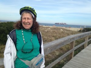
 Feb. 20: We headed northeast of Savannah for the beach resort and historic town of Tybee Island in the Savannah River estuary. Although Tybee is slightly to the north of Savannah, it seems to have a milder climate, based on the vegetation. As I type I am looking at bottlebrush and rose bushes in full bloom. In Savannah, it was spring, with the azaleas just starting to bloom and a lot of pansies in pots. In Tybee everything seems to be blooming at once: azaleas, roses and camelias, lantana, hibiscus and snapdragons. There are citrus trees full of fruit, palms and their relatives and the ubiquitous live oaks and loblolly pines.
Tybee Island is rather unusual as beach resorts go. For one thing, the town is rather far from the water, because there are large dunes above the high water mark which are protected wildlife habitat. For another thing, Tybee Island has had military installations by the water to protect Savannah harbor since colonial times.
The first lighthouse in the US was built on Tybee Island in 1736. Unfortunately, it was built too close to the wave action and was soon destroyed by the sea. A second lighthouse suffered the same fate. The third lighthouse was built further inland. It stood during the Revolutionary War during which the British successfully fended off the Patriot troops. 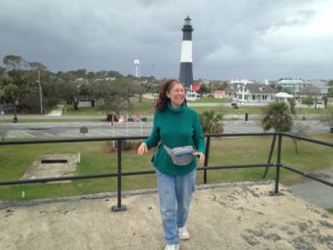 During the Civil War, it was burned by the retreating Confederates, who were worried that it would be an asset to the Union troops. Fortunately (for the Union and for future generations) the concrete building withstood the fire – only the wooden interior stairs were destroyed and they were quickly rebuilt by the Union forces. The old base was used to build the more modern structure that remains and is now a museum, along with several of the buildings that housed the lighthouse keeper and his family around 1919. Although the lighthouse itself was closed for repairs to the stairs, the outbuildings were quite interesting, containing many of the furnishings from the family that lived there in the 1930s.
During the Spanish-American war (1899) parts of the land surrounding the lighthouse was commissioned to form Fort Screven. The resulting battery (upon which I am standing in the lighthouse photo) now looks like a huge beach fortification, protecting the town from moderate storm surges. While much of the fort is now privately owned (and it looks like condos are being built on top) a section has been incorporated into the town museum and has interesting historical artifacts. The town also served as training areas for US troops during the 2 world wars.
 The dunes are nesting places for shore birds and sea turtles and are therefore protected habitat. Long board walks stretch from the roads to over the dunes to the beaches. At the Marine Science Center we learned from the docent that the beach itself is now too wide for the sea turtles. After the mothers have completed their laying, the nests are routinely moved by staff to more sheltered locations in the dunes if necessary.
 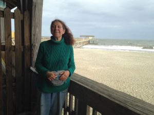 The nests are carefully watched by volunteers until hatching. Finally, after the hatchlings have left the nest, stragglers may be transported for rearing in the Center. If an egg-bearing female has been killed while searching for a nesting site (e.g. if she was struck by a car) her eggs will be taken to the Armstrong Atlantic State University for incubation. The Center had a number of baby diamondback turtles and a 2 year old loggerhead when we visited. All are due to be released to the wild quite soon.
An interesting thought from the docent at the Marine Science Center: In some reptiles, including sea turtles and alligators, gender is determined not by genetics, but by the temperature at which the eggs were incubated. Global climate change could therefore threaten the gender balance in these species. In particular, warmer weather would favor female turtles and male alligators. (https://conserveturtles.org/information-sea-turtles-threats-climate-change/).
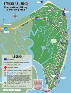 Tybee Island is perfect for biking, as most of the roads are quiet and the entire town is less than 3 miles long. We used our bicycles as the vehicles of choice while sightseeing. We biked all the bicycle paths.
The Savannah River estuary is basically a large salt marsh with a few drier islands. Because of this, Tybee Island also offers some very nice kayaking, although there are some hazards for people like me who are not that familiar with the effects of tides. Our kayak route started from the just inside the inlet at the south tip of Tybee. When I first launched, I was swept rapidly towards the salt marsh and had to fight the current to get back to shore. Being swept into the marsh is not a huge problem, but when the tide goes out, an equally strong current takes you out to sea. I learned that when ocean kayaking it is essential to check the tide tables and time the trip appropriately. As it happened, we launched when the current was strongest. By the time we returned, the tide was high and there was almost no current at all. The tides here are 7 to 10 feet, which is considerable.
Our kayak route took us into the first creek going back north into the marsh. 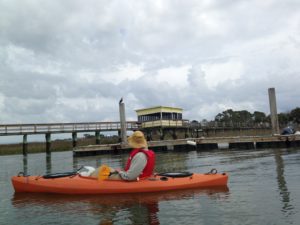 The salt marsh is fed by many meandering creeks, which have a basic flow towards the sea, but which are usually reversed at high tide. Most of these are now lined by homes with docks, which means that the creek beds have been stabilized. I could not help but wonder what the long-term environmental effects of this will be. The current configuration did survive Hurricane Matthew this past October.
The salt march is full of birds – especially herons and egrets. As well, there are plentiful oyster beds. At one curve we saw a colony of tiny crabs. Clearly this is an important wildlife area.
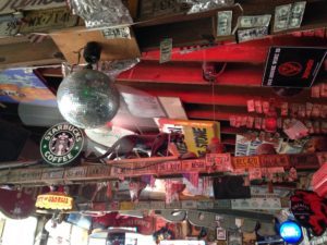 Although the town is full of cottage rentals, it lacks another beach town feature. There are only a few touristy shops as you enter the town, and hardly any downtown. There are a lot of eccentric restaurants/pubs, however. At the advice of a long-time visitor, we went to Huc-A-Poos, which takes this to the extreme. The outside veranda is decorated with a mish-mash of interesting stuff. The interior has a ceiling lined with vinyl album covers, at least one wall of old license plates, a bar lined with signed one dollar bills, old stuffed animals tacked to the beams, an old gas pump, etc.
 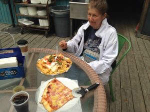 The shot above is part of the wall and ceiling – note the dollar bills, license plates and general junk. Huc-A-Poos also has very good food. In fact, the nachos (pictured) are second in my experience only to Happy Valley Brewery. We highly recommend it.
Rumple spent more time than usual in the RV here. We cannot take him when we bike, and we felt that kayaking might not be advisable in case he had not learned his lesson about jumping out. Dogs are not allowed on the beach. However, there are 2 large dog parks beside the RV park which he did enjoy.
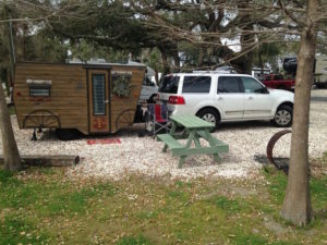 One interesting thing we noted at the RV park was an abundance of very small RVs, some elaborately decorated. I chatted with owner of Nana’s B&B (below) who told me that there was a group of about 30 women who meet several times per year – no husbands, offspring or pets allowed – at various RV parks.
 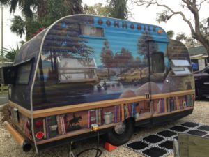 They host RV interior tours to raise money for charity. Since we were leaving before the tour, she invited me in for a peek at her own very elaborately decorated mini-RV. It had all the amenities in a tiny space, and every inch was covered in needlework, arts and crafts.
 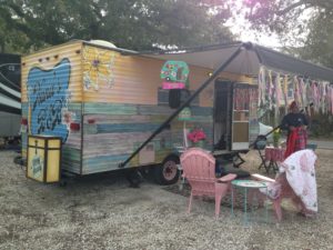 While the “Bookmobile” was painted by a professional muralist, Nana’s was the work of the owner and resembled a weather-beaten shingle house – all hand-painted including the wood grain.
On the opposite end of the spectrum, we chatted with our neighbor who had an enormous 5th wheel RV, which he and his wife use to transport 4 horses for trail riding.